Hiking
-
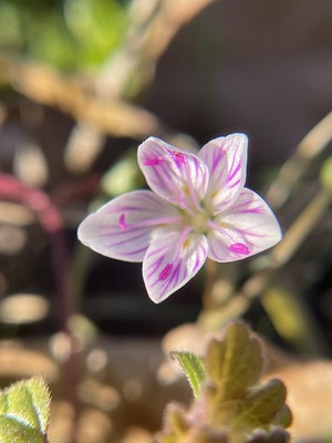
Puttering Around the Confederate Reunion Grounds State Historic Site
Jack’s Creek, which feeds into the Navasota River around the bend to the left of the photo. Virginia Springbeauty, Claytonia virginica A very chilly plain-bellied Watersnake, Nerodia erythrogaster. The Navasota River Hemisphaeric Liverwort, Reboulia hemisphaerica, with both male and female reproductive parts visible. I don’t usually see this species like this, usually it is in its non-reproductive phase. Close up of the female archegonium, the globular structures, and the darker, male antheridiums above. Leather Lichen, Dermatocarpon miniatum Effervescent Tarpaper Lichen, Collema furfuraceum A remnant fireplace, there were a couple of these around the grounds, if I recall correctly. Pennsylvania Pellitory, Parietaria pensylvanica, growing out of the fireplace. Rabdotus sp. I’m…
-
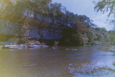
Guadalupe River State Park on Film – November 2024
All photos above were shot on a Minolta XG-1 on expired Kodak Gold 200 35mm film. All photos above were shot on a Minolta XG-1 on expired Kodak GC 400-8 35mm film. To continue from my last post, here are photos from other rolls of film I recently had developed. These two are from expired 35mm film and I really love the outcome for both. It’s giving “looks like 1975” but in reality it was 2024. The Montezuma cypress along the river as well as the rock wall on the river provide excellent backdrops for photography, whether on film or digital. Since we have typically gone to this state park…
-
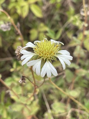
Country Dirt Road Botanical Finds
Gaillardia aestivalis winkleri, white firewheel White firewheel with a nectaring little yellow, Eurema lisa This is a locally uncommon to rare grass, Gymnopogon ambiguus, bearded skeletongrass. I’ve only ever seen it over on the Big Sandy Creek Unit of the Big Thicket. I suspect it may be more common in some of these areas but people generally ignore grasses. Oenothera rhombipetala, fourpoint evening primrose A few weekends ago, Chris took a random dirt road that his GPS said to take to get to the Beaver Slide Trail in the Big Thicket. It was a pleasant drive, lots of interesting plants to look at outside the window. Then we entered a…
-
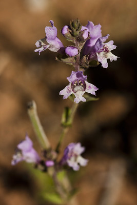
Finding All the Plants
It’s spring and so I am in my happy space–there are PLANTS BLOOMING AND MORE TO COME! I’ve been out hiking a lot recently, trying to wrap up what remains of trails for my Big Thicket region hiking guidebook, and so I have been seeing a lot of interesting plants and sights recently. I’ve essentially given up on trying to keep this blog to the detail I used to be able to and so this is what you are going to get from me now (this is a note for future me when I get mad at past me for not writing about such and such thing.). My favorite place…
-
Gus Engeling WMA in August
Another old draft here, this one from August 2023 and a trip to Gus Engeling WMA. It was one of our trips up towards Dallas when we were picking up or dropping Forest of with grandparents before school started. I can feel the heat from this post just reading through and looking at the photos. We didn’t get a really good trip into GEWMA this last summer due to the spring floods, which damaged access to the sandhill section on the north end of the WMA. We didn’t know it was closed when we were going to drop by and visit and so we ended up exploring the southern section…
-
Thanksgiving at Guadalupe River State Park
Gladicosa pulchra It’s been a hot minute since we went to the Hill Country. Well, it’s been a hot minute since Forest and I have been to the Hill Country. Chris goes almost quarterly either to Austin, or more recently, to San Antonio, for work projects. But it has been since late winter or maybe spring of 2023 since I’ve ventured to the Hill Country for recreational purposes. We made plans for Thanksgiving camping at Guadalupe River State Park, which the last time we’d been there was four years ago in 2020 for Thanksgiving. We also paired that trip with South Llano River State Park. I don’t think I ever…
-
Hickory Horned Devil | Wildlife Wednesday
Back in late October we went camping at Huntsville State Park. It had been several years since we’d been and I needed to tackle some trails there for the hiking guidebook I’m writing. Which, now that I look at my archives, I can’t find that I wrote about that here….??? Oh, wait, I found it, hiding in a life update post from June. Yes, still plugging away on hikes for that and I probably should post an update soon of how that is going! It was rather warm for October at the state park but we carried on and sweated it out. On Saturday of that trip, we had one…
-
Southern Twayblade Orchid (Neottia bifolia)
I have finally given up any pretense of writing in a timely manner here. Or sticking to a frequency schedule. Life is busy, writing time is scarce. Let’s roll back to February of this year when we hiked the Four Notch Loop of the Lone Star Trail up in Sam Houston National Forest, where we did a quick overnight hike to see the southern twayblade orchids. Unfortunately I don’t know when we will be back on the LST or anywhere in Sam Houston because the Forest Supervisor just issued a major closure order for a significant portion of roads and trails in the NF due to historic flooding events in…
-
Swooning Over Plants at Gus Engeling WMA – June 2023
I don’t know if I can express how much I love Gus Engeling WMA. I wish I lived closer to it, though perhaps it wouldn’t be as special? Nah, I think it would and I would probably know its ins and outs a little better. I’m constantly drawn back to thinking about south Florida and how “close” everything was, how driveable within a 1-3 hours a place could be, most places in the 1-2 hr range and many within the 1 hr or less range. Feel like going to the Keys for a long day? Done. More in the mood for interior slow moving creeks and rivers? Done. Dwarf cypress…
-
Thanksgiving at Lake Brownwood State Park
The lake was very low, still feeling the effects of the drought. Don’t cut hearts into the prickly pears, y’all. We made Thanksgiving camping reservations a little later this year and paired with only having the four days off instead of taking the entire week, we needed to go somewhere mid-range, not making the trek to South Llano River SP or the Davis Mountains as per what we’ve done frequently in the last several years. Plus, we’d already hit the Davis Mtns back during Spring Break in 2023, though I could easily go there twice a year or more if time was available. Lake Brownwood is “out there” in that…