Thru Hike FAIL: Part II | The Northeast Texas Trail (NETT)
On Sunday morning, though we had spent plenty of time in the tent already over 12 hours, we struggled to want to get out of the warmth of the sleeping bags. We hopped out, packed everything up, emptied bladders, and threw down a bar or two into our stomachs. We were around 2 miles from Avery which boasted a gas station that had a cafe and we hoped to stop there for a quick breakfast.
The sun was out, which was an optimism booster, and though I was feeling sore from the day before I was ready to go. At this point in time I was still feeling that we would finish the trail. It was about 20 miles to Clarksville and while I didn’t know much about the upcoming section, I didn’t have any reason to believe it was going to be bad. My plan had been for us to camp just outside of Clarksville, stealthing somewhere on the otherside of town.
As we arrived closer to Avery, houses lined the north side of the trail and U.S. 82 veered off to the north a bit, diversing from its adjacency with the railroad bed. Avery was very quiet, a one-horse kind of town. You could tell that in the railroad hey-day that there had been some activity in the area and even the modest ‘downtown’ might have once been fairly busy. No one was up yet, well, maybe a couple of folks, but it was Sunday and chilly. The trail opened up wide into big fields and as we approached town it was prety evident the gas station wasn’t directly in town and was likely located somewhere on U.S. 82.
We stopped by a painted window on an old building that announced a tomato festival, took a few pictures, and then kept on walking. We were planning on using the gas station to buy some water to get us to Annona for lunch, but without the gas station we were out of luck. Just passed downtown we saw two churches and it was early enough that no one was there yet. Using a trick we did on the Florida Trail, we found a spigot on the outside of one of the churches to fill up our bottles. I was just hoping we weren’t going to get the burpy/barfy sulphur filled water we got at the church on the FT. I sipped it, all was good.
Finally on the west side of town we saw barbed wire and I thought this would be our first foray into barbed wire fence jumping/crawling through on the trail. Luckily there was a gate that had been left open just to the side and we went through that way. The gate led to a higher, cleared and mowed buffer strip next to the property owners barbed wire to the north of the trail. The railbed was sunk lower into the terrain and was overgrown but a snail-trail, a very narrow singletrack, wove through the brush.
We’d been following bicycle tracks over the last day, as I had seen that three guys were attempting to bike the trail too. Somewhere along the way the tracks went from three to two and the two tracks had continued on through the brush. Chris and I walked through the brush, crawling over downed logs, through thorny vines until we came to an even more overgrown area and we stopped for a minute.
The debate and our beginning frustrations with the bushwhacking began. Chris argued that we could viably use the mowed area to the side, as it was still within the old railroad right of way, just not on the old rail bed. I argued that he had been wanting to follow the trail exactly and to be the first person to do it and it seemed sketchy to deviate. It was largely semantics. I should mention that just to the south about fifty feet was a farm road. We could have easily walked on that, too. It was decided that we should do our best to walk along the actual railroad bed and if at any point, other than using a road to get around a water feature if a bridge was out (ie: the road had a bridge), we weren’t going to walk on any road. I hadn’t come to hike the trail to walk on roads. This wasn’t like other developing trails that didn’t have trail access and rights through private property, where a road had to connect the trail between properties, there *was* a trail here—it just hadn’t been maintained properly. If it ever got bad enough that we had to roadwalk, we were done with the trail. That was our decision.
We forged onward and this small section of overgrowth ended at another gravel road, us ducking under the barbed wire, crossing the road and then hopping a metal fence to another property. A sign posted the Original Texas Land Survey information (Texas’ version of the PLSS) for the property and we kept on going. The trail was overgrown to some extent but not as bad as the last section. We weaved through shrubby trees and for the most part it was pleasant. We hopped a couple of other barbed wire fences as we crossed property lines and entrance roads, and at one point walked in front of someones house.
There were a lot of open dumps along the way, areas were locals had dumped trash. There would be a lot of cleanup needed if this trail was ever going to be decent looking in the future, aside from the brush clearing that is. We stopped mid-morning for a snack and estimated we had about four miles until Annona. To our south was pasture for the most part, to the north the same gravel road, though it had switched sides from being in the south to the north.
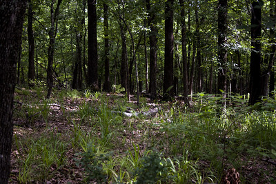
After our break we walked again until the gravel road turned and the trail stopped paralleling. Up ahead we spotted two dogs lazy walked around the trail, in-and-out of the brush. By the time we caught up to where they had been there was no trace of them. The trail got began getting wet here, large pools of water where the trail sunk into the terrain around the general topography. We weaved around them, hunching up along the sides to keep from getting wet. There would have been good campsites in this area, on the top of the right-of-way, and would have been relatively peaceful since no road was nearby.
Ahead, the trail had been rerouted around a really wet section, likely the work of local ATVers, and then the trail began wide and open and very nice. Being semi-remote, I wondered if the adjacent landowners kept it up or what. I was enjoying this section so far, in the woods, open and clear. Quiet. We crossed a couple of old bridges, peering down into the creeks below. In the future they would need some repairs, this could definitely be a problem for this trail in the later on, finding the money to keep the bridges in good condition.
Eventually we found ourselves on the east side of Annona and in a clearing, a very overgrown and weedy clearing. The temptation to walk on the road that had appeared on the side was great. To be frank, this was a shitty area. And then I threw my hands up and wondered how the hell this wasn’t clear when it was so close to a road and right at the town? A weed-eater, a lawn mower, would easily keep a single-track open for walking. Oh, I was annoyed.
Houses abutted both sides of the trail, and barking dogs were alerted to our passing by. We made it through the brush and onto short-grassy areas that passed old warehouses. This was appearing to be another one-horse town and again we were hoping to hit up a gas station for lunch. At the main road in town, where the railroad crosses, we looked up and down and saw no gas station, until out of the corner of our eye and hiding behind some trees we saw the tell-tale red of a gas station pavillion. It appeared to be about a half mile walk up to it, located on U.S. 82. We opted against walking to it and instead would eat the lunches we had packed.
The otherside of the roadway led to more of the same crap we’d just walked through. I was hungry—hangry—and sore and wanted to stop. Chris, like always, wanted to find somewhere decent to sit for lunch. My leg was acting up more since I was having to lift it up and over piles of tall, dead grasses. I had spotted a pile of declaying logs, already covered in a bit of vegetation and moss. I ducked under the eastern red cedar that was providing cover right there and sat down, pulling out my sandwich round and a Justin’s almond butter packet. Reluctantly Chris came over and we ate lunch. I looked at the GPS and it was about 7 miles to Clarksville. Hoping that this grass crap didn’t last too long, that maybe we’d find good trail on the other side, we could get to Clarksville in about 2.5 hours, 3 tops. As we were sitting there Chris decided that perhaps we would even just get a room in the motel there for the night, to stay warm and out of the impending bad weather, and to wait out any ice storm that may await us the following morning.
After lunch we found more of the same on the trail. It was nearly impossible to stay along the railroad bed and instead we went up on the grass once again, wading through the river of the stuff. Finally we reached the end, at an industrial facility. The railroad bed behind the facility had been kept cleared here and despite a few puddles, was ok. Towards the end we saw a pile of very old cars pushed into the ditch to the south of the trail. The cars looked to be from the 20s or 30s, rusted out, relics of days passed.
We’d been hearing the traffic for U.S. 82 get closer and then we found it—below us. The road had been carved out down below in the hill, the old railroad would previously been a bridge over the road, but that was gone. We had to hike down the hill, dash across the road, and then climb a hill as if it was the only mountain around. From the east side of the hill looking across the road, we saw two impressions of bike tracks climbing up the hill. The bicyclists had made it this far too.
Once up the hill the trail wasn’t too bad, the nasty grass was gone and it was semi-clear. We passed a group of houses on the south side of the road, junk yardish with barking dogs, but we kept our head down and walked on. The good trail on the railroad ended and we jumped up to the top of the right of way where it had been cleared and it was evident this was used as a pathway. This was all well and good until it ended and we thought we lost the trail. I crossed some thick vegetation to the south and looked down and could see the distinct pattern of the railroad, only this time it was over grown.
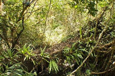
This was the beginning of the end. We began walking, sometimes it was just bad, other times it was bad-bad, and then other times, like the first time we crossed an area with bamboo that was threatening to take over an old bridge, that was nasty-bad. I lost track of time as we wove around the thick vegetation, trying to escape the claws of Smilax, blackberry, and rose vines. Of course there were thorny trees—I’m not sure what those were as they were defoliated. Trifoliate orange? Crataegus? Maybe locust? They were nasty too.
We walked and walked and while frustrating, we weren’t through yet. In one thick area we saw that the ditch next to the railroad to the north looked relatively clear, so we climbed down to it, only for it to narrow later as it approached a creek, forcing us back up the slope. I about lost it as I climbed up the slope, fighting with vines and trying not to poke myself in the eye with tiny tree limbs that whipped back in your face. I’m all for bushwhacking if there’s a good purpose, but the purpose of bushwhacking here was quickly losing its appeal.
Back on the trail we found ourselves facing yet another bamboo thicket. We’d passed a couple of others since that first one we saw, but this one was particuarly nasty. It appeared inpenetrable. We hadn’t seen evidence of the bicycle guys in a long time and figured there was no way they had made it through here. Even the bamboo didn’t seem to have much in the way of movement, broken sticks of bamboo or anything like that. We found a small hole in the middle which we crawled through, getting us to the south side of the trail. I saw the road and a bridge across a creek so I told Chris we could go across that to get to the other side. He agreed and as we started making our way down the slope I heard what I thought was the rustling of the tops of the bamboo. I stopped for a second and realized it was sleet.
We got down and crossed the bridge, the sleet coming down with a smidge of rain drops, bouncing off of us and melting as they hit the ground. Avoiding the bamboo that was on the other side of the railroad bridge, we found an area to go in a bit further down. I’d asked Chris what time it was when we’d come down the slope, only 2:45 and he said we were nowhere near Clarksville. I knew, I told him I figured we had at least four miles left, to which he agreed. We were not making good time at all in this crap. With the clouds building up, and darkness setting in earlier now that we were fast approaching winter, our hiking time of the day would be reduced.
With the sleet I wanted to put on my rain jacket but Chris basically said that unless I wanted to rip it to shreds that I couldn’t. That went for the down jacket as well. I was pissed, I didn’t want to be wet and cold, I hated the #*%@tastic overgrown trail, and wanted to set up the tent. I told him we should get water at the creek now so we could just find a place to stop. And then he threw back that if we stopped now we’d still have to hike in the same stuff, plus more of it, tomorrow in the rain or wintry mix.
I had been mentally up for spurts of bushwhacking, not miles and consecutive miles of it, without the ability to keep warm and dry. I told him I was done, that I wanted to quit, that it wasn’t fun anymore. Why hike something when it wasn’t fun? I started crying into my poles, my gloves clenching the tops of them. He said we could quit now, but if we continued hiking that we weren’t going to quit after this. Chris isn’t an easy quitter, but I don’t think he was having fun either. I didn’t really want to quit, I did indeed want to hike, had been envisioning finishing the damned trail up until it started sleeting.
That’s why it was so hard for me to make the call. Chris got out his phone, making me be the one to dial his mom so his step-dad could come get us. I handed the phone back and forth to Chris twice, bawling at the same time. Meanwhile, I put my rainjacket on and packcover and tried to keep dry as we stood there. Finally, I dialed. It was over. I felt relief to be going somewhere warm, and then anger at myself—for quitting but also for agreeing to hike the trail in the first place—knowing that it was overgrown–, if we’d done the Lone Star Trail, I know we would have finished that hike—not completing the trail felt so stupid. But, not enjoying it was also stupid, too.
I gave his step-dad the town we were headed to and said we would be walking along the shoulder of the road and would likely make it to Clarksville, now that we had an easy walking terrain, before he arrived in about two hours. We’d find somewhere to eat and get warm while we waited.
As we walked along the shoulder of the road, I thought about what was needed for the trail to be actually enjoyable. How much work was going to be needed. There were few people willing to bushwhack it, and thus far no one had made it on the length of the trail by bushwhacking the crap sections. Our mood lightened as we walked on, wishing for the water tower in town to magically get closer a lot faster than it did. Finally we did make it to the edge of town and instead of continuing to parallel the trail we took a turn down Main Street to see what we could find to eat. It was another mile before we passed a Dollar General, then a closed Mexican restaurant, and finally we saw the Golden Arches and decided that was where we were going to go. The tall M seemed closer than it actually was, and we found it on the far end of town, beyond the old town square.
I had already broken my vegetarian rules that weekend so I kept at it with getting a Big Mac. It’s been years since I had one and while it was delicious at the time, upon reflection and without 20 miles of hiking on me for the day, it sounds completely disgusting now. But, that’s what hikers do when they get to town, they gorge on the crappy food and we did that as we were piled up in a booth at the back of the Clarksville McDonald’s.
Night did come at round 5:15 with the aid of the cloudy sky. I wondered if we’d have even made it to town or not with the continued bushwhacking. As it was we rolled into town at 4:45 having left the spot we were deliberating at a little after 3, and that was by walking on the shoulder of the road.
I have some final thoughts and then photos/video to come. But that concludes the 40 miles in two days we did on the Northeast Texas Trail.

3 Comments
Curtis
Well poop. If the weather hadnt been cold I’m sure you would have toughed it out.
Moosie
Well maybe if you had a tractor w ya,it would have helped.
Tracy Rumsey
Hi Guys. I just came across your blog about your trip. You should be very proud of your selves. that stretch from Annona to Clarksville pushed me to the road several time. I am sorry that you had to bail out at that point. I have since organized a trail work day that cleared about 3.7 miles of the stuff you are taking about. We started in Clarksville and worked our way back towards Annona. It still needs a lot of work but its a start. I am trying to set up a few more trail work days and would love to have you guys come out. it would be a great way to scout out sections of the trail that you did not get to see and plan your next hike.
since you were able to make it through that section the only thing that should give you a lot of trouble is the Paris to Roxton section which I am trying to organize a work day for some time in April 2014.
I hope you try it again! it was an eyeopening and changeling trip but worth it. If you are interested we could plan a group trip.
Tracy Rumsey