The Whites: A Definition
The Whites
-noun
1)a mountain range in N New Hampshire, part of the Appalachian Mountains. Highest peak, Mt. Washington, 6293 ft. (1918 m).
2)Ass kicker
3)Vermont + Pennsylvania combined. Mud + rocks.
4)Mileage reducer
5)Beautiful
6)Exhausting
7)Crowded
Ahhhh….we’re done with the Whites!!! THANK YOU GOD! Ok…so I’m a touch dramatic, but wow, what a wipe out, tiring experience. After doing Moosilauke (which wasn’t as bad as I thought it would be) and getting slowed down on the north side of Kinsman Notch we had to re-think our mental game in terms of mileage. Goodbye 15+ mile days. We couldn’t even think it. When you look at the book it seems ‘easy’ and doable. Sure, that 17 or 19 mile stretch doesn’t look so bad, until you are faced with hand over hand rock climbing and making your way down wet rocks, rocks covered in roots and sliding down surfaces because figuring out a way down any other way just doesn’t seem possible.
In many parts our average speed was 1.5 miles an hour. This is depressing from going 2.5-3 (even more at times) mph in other areas. And even thinking that anything else was hard previously is laughable. Sure, it might have been hard because it was hot or I was in a bad mood or it just took a little longer, but we did some big climbs with some seemingly nasty stuff and still managed 17+ miles a day, even did some over 20’s and had no problem. Our biggest day in the Whites was from Lakes of the Clouds hut, just below Mt. Washington, up and over the Presidential Range and down into Pinkham Notch, which was 15 miles and that beat us up pretty bad.
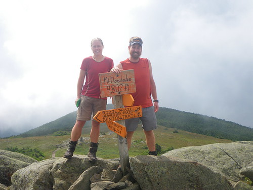
We did Moosilauke early in the morning and it wasn’t a bad climb at all. Took some time, but we made it up and we all hung out up top for about an hour. It was cloudy at first but they blew by us quickly and Chris and Merf attempted to make a kite out of her tarp; it failed.
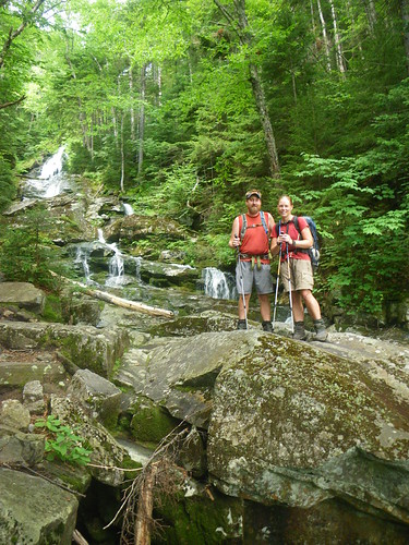
My big thing about this mountain was the coming down the other side. We’d heard so much about the descent that I was insanely nervous and absolutely didn’t want it to rain. Of course it wasn’t nearly as bad I as I thought, but I can see how in the rain it would be worse. There are wood blocks mounted to slabs of rock so you can get down, rebar to grab on to and a stream flowing right next to the trail.

At Franconia Notch we met up with blog reader Patrice and her husband who live in the area and they were kind enough to bring us trail magic and drive us somewhere to eat. They were also super nice enough to let two other hikers tag along to get some resupply! Thank you so much and it was awesome to meet you! They are going southbound next summer so I will be sure to announce it all so you can follow her, too. Oh, and it was crazy, the pub/restaurant we ate at in North Woodstock , we ran into Lion King, whom we originally met coming down from the ridge past Thomas Knob shelter in Virginia. He’d just broken his poles! He even remembered us!
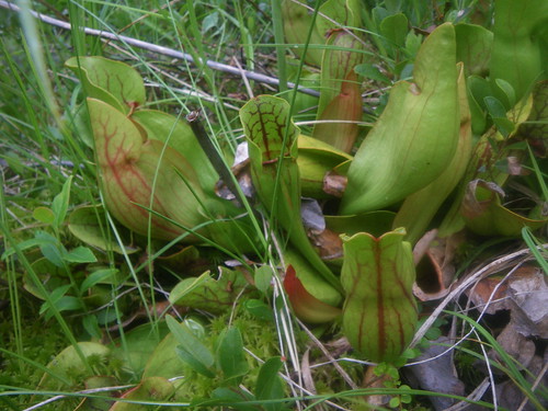
we found some pitcher plants on a boreal bog near South Kinsman! Very neat!
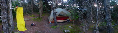

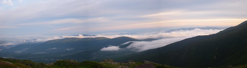
The big thing about the Whites is that you have to pay to tent or stay at the huts. It’s really, really, annoying. But…you can stealth camp. We lucked out and the first tent site we name dropped an AMC ridgerunner from CT to the caretaker and he let us in for free! Score! The next two nights we stealthed and this photo is from the spot on Mt. Webster. It was really cold up there with the wind, but it was a very awesome spot.

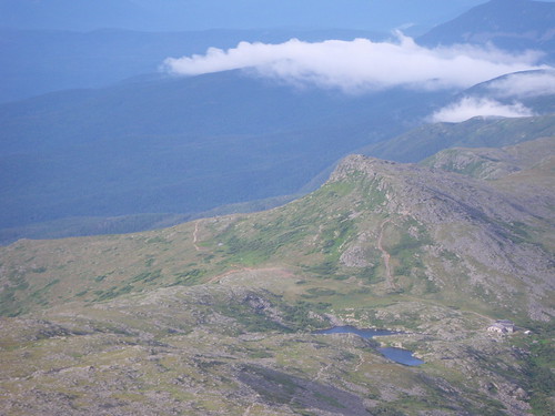
By far the best part was being above tree-line. Also, the scariest part. We’d just left Mizpah hut and were heading to Lakes of the Clouds hut when we got up top and saw a storm front was blowing in. Lightning was in the distance and though it isn’t totally kosher to set up a tent in the alpine zone, we threw it up in a little alcove and rode out what turned out to be a wimpy little storm. It stayed chilly and windy the rest of the way up. That is Washington in the background.

We got up at 5:30am the morning we summited Washington and it was perfectly clear! This was what I was hoping for all along! SCORE! We were on the summit probably 45 minutes after leaving and tinkered around for awhile at the top. Then it was down trail towards the other Presidentials.
Overall the toughest parts of the Whites were coming down into notches (gap’s…valley’s) and leaving them. Generally. We had an awesome 2.5mph stretch from Zealand Hut to Crawford Notch, but flat trail was few and far between. The worst climbs by far were South Kinsman and the Wildcat’s.
We made it through most of the weather except for yesterday when we got a really nasty thunderstorm while on top of the Carter range. At one point we were above treeline and the lightning and thunder got closer and we tried to book it as fast as we can, but of course 2 miles from camp and coming down North Carter (which had steep rocks and rocks you have to slide down or precariously try to walk across) the bottom fell out and we ended up getting soaked and walked in the Appalachian River instead.
Anyway, we are in Gorham resupplying and trying to dry out. We’ll be in Maine on Saturday. The next week will probably continue to be tough but we’ve heard that the second section of Maine is much easier and we can pick up our miles again.
Still can’t say when exactly we’ll be done, but I’ll just estimate 3ish weeks! Insane! And relieved. I am ready for not moving my body at all for an entire day.
Oh, not sure when the next computer time will be so I will probably be doing the call my brother and let him post thing. 😉
PS: HAPPY EARLY BIRTHDAY TO MOM! She’s going to be…shhhh…50!! 🙂 You can think of her on the 27th.
You May Also Like
12 Comments
Gayle
Love the update!!
Alisa
I’m living vicarously (sp?) through you as I read your blog. I miss you and look forward to seeing you and hearing about it all in person!
Love-ya,
Alisa
Mom
Oh I love the pictures!!!!!!!!!!!!!!! Can’t wait to see them all. I love you!!!
Marc
You guys are seriously HARDCORE! Unbelievable! And extremely impressive. Can’t believe how far you’ve gone. Eliana and I are enjoying some insanely scenic hiking and exploring on Kodiak Island, Alaska. We love it here so far, but are super sore from a steep hike (Barometer Mountain) we did on Monday. You guys probably would have finished in a quarter of the time it took us. Anyway, good luck with Maine!
Prem
BTW, that is Sarracenia purpurea, which grows all the way south into north Florida (there are plentiful purps in the bogs around Sumatra, FL).
—Prem
Chelle
love you miss you and omg at the calves mountain woman!!!! 🙂 i so can’t wait to see you and give you big hugs and hear your stories! (or if you are totally tired of telling your stories we can totally talk about boring stuff like dusting LOL
Stephanie H
Wow! Sounds tough in some parts! It’s beautiful out there. Cool weather in summer seems strange to us out in Texas!!! I’m glad you guys are doing okay and making it over the mountains. I can’t believe you’ll be done soon! That’s crazy! I’ll be thinking about you guys! 🙂
Patrice
So glad we were able to meet up! And we are glad you survived the Whites and the slowdown!!! Hopefully Maine is memorable in a good way!
Heather
Wow, those pics make me think: What an awesome world.
Y’all look so great and happy! I hope your mom has a wonderful birthday, and your family has a fun celebration for you both when you’re all done! 😀
Pingback:
Pingback:
Pingback: