The Greatest Mountain
The alarm went off. Was the sky clear? Yes, the stars were out. We reached over and twisted our NeoAir tubes to deflate them, stretching in our sleeping bags and yawning. It was too early. After fumbling for our headlamps we started moving about, getting dressed, rolling up the air mattresses and stuffing our bags into their compression sacks.
Sitting on the side of the tent platform at The Birches, Blue Rooster came by and said he was getting ready. Cubbie & Dilly Dally were in the other shelter getting their items together. We ate a few granola bars for the early morning breakfast and quickly put everything together in our packs.
We were off on an adventure. Or the final adventure to a long adventure.
Inside the front porch of the ranger station we found someone sleeping. Sorry, but we had to switch our some gear, ditching anything heavy we didn’t need for the final five miles. No use for a sleeping bag, Keen sandals, cooking gear. Throw it into the trash bag to leave behind. Without the extra weight we felt light and airy, able to bounce around. Just some water, food, rain gear and extra clothing.
We crossed Katahdin stream, through the campground and were off. It was 2am. I lead the way up the Hunt Trail, the name of the trail that the AT follows up Mount Katahdin, this Greatest Mountain that the local Indian tribes call Maine’s tallest peak. I’m the slowest one so it’s easier to keep everyone behind the slowest person.
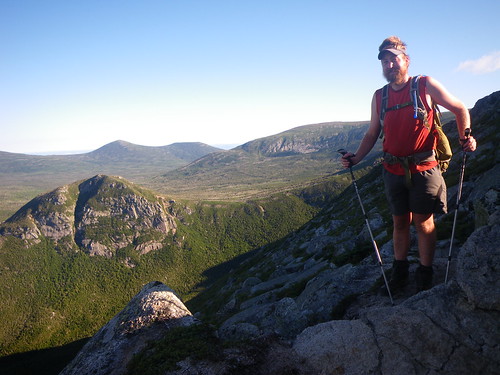
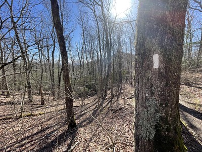
Lights are on full blast, to scope out the roots and rocks that we might stumble upon. We cross over a bridge, see the privy that is located a mile up the trail. That was a quick mile. We finally start climbing, lots of nicely placed rock stairs by the Maine Appalachian Trail Club, then up some big rocks. Finally we come to a spot where water is flowing on the trail, trying to side step the puddles in the dark, careful to keep our shoes dry. We pull ourselves up by using some trees, our hands, other rocks, to keep moving upwards and onto rocks that pose tricks for us to continue. Eventually the confiers become smaller; we are nearing tree line.
With a turn around a rock, the wind howls, the stars are bright and it is pitch black outside of five head lamps on the trail. It becomes a bit scary, finding that we have to manuvere our way up large boulders, several having rebar placed in the perfect position to pull ourselves up or place a foot. The white blazes are well marked every few feet, though in a few sections we get confused; is it that way or this way? Of course we have to go down to go up, this is the Appalachian Trail after all, so yes, it is that way, down through the trees and into some protection from the wind, at least for a few minutes.
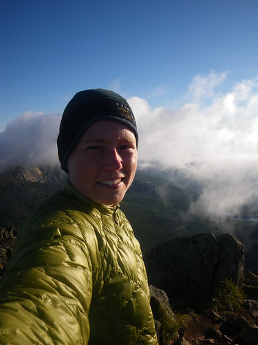
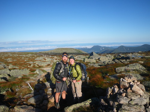
Soon we are completely above tree line, following white blazes over large boulders. Still leading, I pull myself up rocks that look intimidating, squeeze through sections that I can barely fit through. The wind is still blowing and it is getting pretty cold. I have my warm wool hat on to keep my ears from stinging. We’re all talking, looking around us. We can see the outline of some thunderheads to the northeast. We’re all hoping they don’t blow our direction. We see the lights from Millenocket in the distance, and further away, is it Bangor? Finally everyone gets too cold and starts putting extra layers on and we take a few minutes break. Is that the peak we see up there? Probably not, there are always false summits.
I spot the white spray paint on a rock that says 2 miles. We have two miles to summit. Continuing our way up to the summit we are all hoping is the summit, we eventually see a sign. Could it be? Is it the sign? We joke that it is probably a fake sign, and sure enough it is just a small sign advising people to stay on the trail to avoid damaging the alpine vegetation. By this time we’ve reached the tableland, the flatter section of the top. We keep walking along, bouncing off rocks on the path when we finally see a sign for Thoreau spring and the mark for the 1 mile to the summit. Which way is the summit? It’s probably the part that is covered in the clouds, a light fog drifting over it. Damn, we all hope it blows away.
The sky is becoming light in the east. We’re getting faster, more excited, but we still have to go up the mountain more. By the time we start climbing more MATC stairs the fog has drifted away, the sky is brighter and our head lamps are turned off.
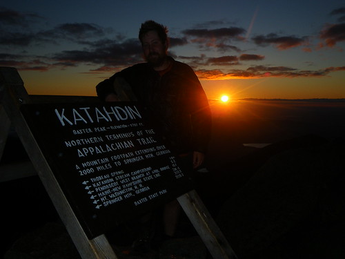
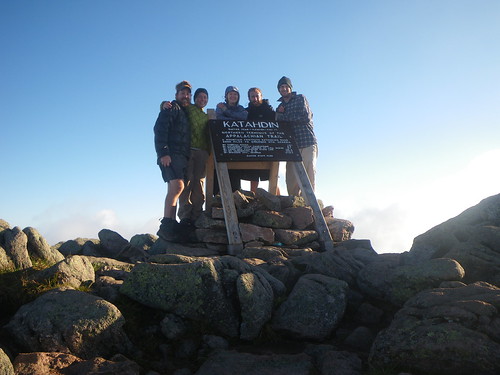
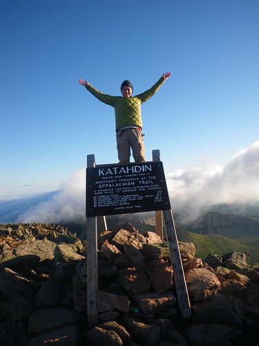
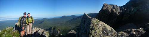
And then it was there. The Sign. The one we dream off the minute we left Springer Mountain, Georgia. The sign we all walk to. We stop 100′ away, maybe more, so Cubbie & Dilly Dally can take a photo of us walking up the last bit of the Appalachian Trail. And then we keep walking.
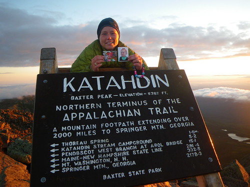
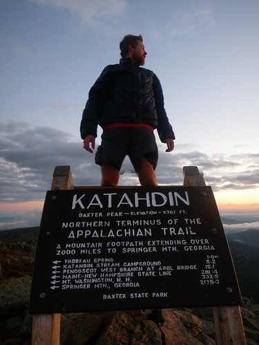
And we’re there. On the summit the with the sign. We’re relived, stoked, excited, in awe of the awesome beauty of the sunrise that is unfolding before us. Our summit was just after 5am. Three hours to the top. None of us can believe it was three hours, it didn’t feel like it, nor did it feel like four thousand vertical feet of elevation gain in five miles. It is such a beautiful site. And words just can’t explain the feeling of being there.
Only five of us at the top for the sunrise summit. No crowds, no day hikers. Just five thru-hikers who have busted through 2,179 miles to be there. We stayed for two hours, eating M&M’s and other food, taking photo after photo, nearly getting dragged off the mountain by a kite and losing said kite (that story later), the other three smoking cigs that were left up there by someone else, probably a thru-hiker, discussing the intense insaneness of the Knife’s Edge, talking about our favorite parts of the trip….
We left down at 7am. It was a completely different hike on the way down since we hadn’t seen what we’d come up. Going down is much harder than coming up, scooting down rocks, easing your way around, trying not to fall. I was amazed at what we’d climbed up at night and couldn’t believe how narrow some of the areas had been. Adrenaline had been our power that pushed us up the mountain. We were down by 10am, passing hoards of other tourists, most in amazement that we’d left so early, many congratulating us on our accomplishment and some asking if they were half way or even near the top (sorry…not quite).
And it was done. We had thru-hiked the Appalachian Trail.


I have to blog about the rest of Maine that I haven’t covered and then I plan on doing a retrospective of each state with photos that haven’t been shown here, when I get home. If you have any questions about the trail, hiking, whatever, ask away and I’ll answer them soon!
What’s next for us??? Hanging around Maine for a few days, heading to Texas and after that we’re not sure. Looking for jobs and trying to find a place to live, but doing a lot of fun side trips and getting into photography again will be on the agenda, too. Thanks for reading and I hope you stay around! Oh yeah, it was a Class I day and we were #’s 103 & 104 at the park.
You May Also Like
24 Comments
Heather
Congratulations!!!
Curtis
You took your nieces to the top! 🙂
Van
Congratulations guys! It’s a long way from where I first met ya’ll in NC. (My son and I) Job well done!
dad
you did good
shelly
Yet again I say YAY! 😀
Joe
I can’t tell you how proud I am of you two and amazed at what you have accomplished. My first introduction to the AT came with Bryson’s book and made me feel it was something within the grasp of normal people and a superhuman feat all at once. I wish I’d been able to meet you out on the trail when you came through.
Good luck with Texas.
Taylor
WOW. Georgia to Maine! Congratulations!
Kim
I honestly teared up reading this. I’m so proud of you! CONGRATULATIONS!!!
Meghan
Great story, Misti…it gave me goosebumps! I am so so proud of you and Chris, you two are so awesome it’s hard to describe. I can’t wait to talk to you and hear all about it. You are seriously my hero!!! 😀
Patrice
We are so happy for you!!!!!!!! GA2ME2010!!!!!!! You did it!!!! Great photos!
Sugarbush
Hey guys–
We never met you but were ahead of you for a long time, then (somehow) behind you, without crossing paths. Looks like you had an amazing finish. Your photos are GORGEOUS. Dethmarch and I also hiked up for sunrise and had a pretty similar experience, with the most amazing night-hike up the Hunt Trail and an intense trip down the Knife Edge. But… here’s the amazing part: we FOUND YOUR KITE!!! I was wandering around up top (we finished the 15th, so it was there a while) and thought I saw some trash, maybe a plastic bag or something, so I went to get it to pack it out, and discovered a beautiful kite! We’re still untangling it and hoping to learn to fly it, but if it means something to you guys (sentimental!??) I’d happily mail it to you. It’s a great kite, and a beautiful shot of y’all flying it up there.
Anyway, congratulations and let me know about the kite.
Sugarbush
Kasie@~The Art of Life
I am so proud of you!! And I mean that with all my heart. So many people talk about dreams and hopes but never do anything about them. You followed your dream and you made it come true, step-by-step. You are truly an inspiration to me!!
Nathan
It’s great to see this useful post on dog training.
I have a question however. How do you train an older dog?
google.com
Prior to do anything speak with friends and family regarding your situation to make certain this is
really the appropriate move available for you Most loan companies have a few requirements designed to qualify any person to receive the cash
payday loan or a cash progress
Pingback:
Pingback:
Pingback:
Pingback:
mywebsite
Do you have any video of that? I’d care to find out some additional information.
Pingback:
Pingback:
Pingback:
Pingback:
Pingback: