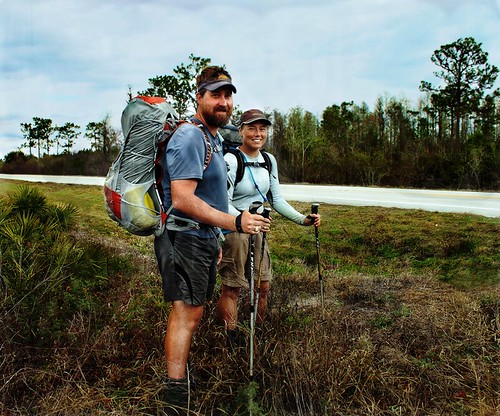
Florida Trail Tales 3: SR 60 to US 192
As we left River Ranch I noticed the sky had clouded over a bit. We had a road walk to connect to another road walk, this time we were headed for S.R. 60, listed in the book as being incredibly full of traffic and quite dangerous to walk on because of a narrow shoulder and sloped grass sides. Our go to find-somewhere-at-20-miles-and-stealth wasn’t going to work here. So, we’d looked on the map and decided that we’d go to where it said “information” on the map at one of the lock’s at the Kissimmee River and S.R. 60 and hope it was good enough to pitch our tent.
On our way out we passed where an old section of the Florida Trail ducks back into the woods. The map lists it as closed trail now, and I’m assuming it is closed because of Everglades restoration activities near the river, but I don’t know for sure. There is a small dirt parking lot to an entrance to the Kicco WMA here with a port o potty as well, so if your mileage put you here this would be a good place to camp for the night. But, again, we were headed for 18 at least and didn’t want to stop short since we had to make it to a particular place for a food drop in two days.
When we arrived at S.R. 60 it was clear this was going to be a miserable walk. Luckily we didn’t have to go but maybe a mile or so to the place we thought we’d stealth. When we arrived we found a construction site at the lock but just passed that was a boat ramp and a decent space to set the tent up. The parking lot was full of empty trailers, the boats still out on the river. Eventually the boats slowly returned from their day on the water as we made dinner and set up camp. Our biggest worry was that a cop would come by an question us, but luckily no such thing happened. The only annoying thing was the sound of traffic through the night and some of the light from the construction area seeped into the tent. I had ear plugs, however, and Chris slept without them.
We knew it was supposed to possibly rain the next day, so when a few minutes after waking that morning and it started storming, we weren’t surprised. Lightning, heavy wind and rain kept us inside for awhile but after listening to the radio and hearing it was going to be nasty for most of the morning and we had 24 miles to do, we decided to finally get out of the tent. Now, when it is pouring outside, you do everything you possibly can inside the tent, even eat breakfast if you have to. We are mostly strict about not eating in the tent because of food debris attracting bugs, mice, and bears in certain areas, but who wants to eat in the rain?
Despite the rain there were a few people who waited out the lightning and launched their boats into the water. We found out from one of them that the heaviest stuff had passed and it should clear up as the day went on. This was good news as we headed down S.R. 60 in the rain. I was not looking forward to getting sprayed with water from oncoming traffic.
It would be at least an hour and a half or perhaps two to get down the road and into a natural area again. Traffic was insane down the mostly two lane road with the occasional passing lane. As we walked we noted that there was definitely not a good stealth site in this area and we’d probably hit the best possible location. A few times we had to jump further off the shoulder because of the passing lanes; idiots who waited until the last minute were close to causing wrecks and I didn’t want to be involved in any of that.
Finally we saw a brown sign in the distance and it gave us a glimmer of hope we were almost off the road. As we inched closer (it seems like inching when you walk next to 70mph cars) we were pleased to see the sign said Three Lakes Wildlife Management Area. We turned off the busy road to walk down a dirt road bordered by cattle ranches. Here we found our third otter in as many days scuttling across the road. At the end of the dirt road we saw the official green sign marking the entrance to the WMA. To the west we saw a field of deserted RVs and a sign that said something about the FTA. I sat down and took a break while Chris went to investigate and found no one around.
Next up we followed the eastern fence line boundary into the WMA, which was unfortunately a fluffed up fire lane. Seriously, why does the trail insist on following these things? Difficult to walk on; I hate them! I mean, find the hardest part on the beach to walk and you can simulate walking on these fire lanes. Eventually we left the fire line and headed off into a thicket of palmettos. Thankfully it had stopped raining and was mostly cloudy at this point but it would have been very hot had the sun been out. I could see a mile or so off that we were heading for a hammock to which we finally arrived at.
Once inside the hammock it felt a bit like ‘home’. I mean that in the swamp exploring kind of home way. The cabbage palms and some of the floor of the hammock were covered in moss and there was a very tropical and ancient feel to the place. There were a few mosquitoes, though, one reason to get back into the open air. We reached a campsite in time for lunch and to dry out the tent from the morning. I called my brother and sister in law because they had a doctors appointment that day to find out about their newest pregnancy and I wanted to see if it was twins like we were all joking it would be. It wasn’t, just a single little baby in there, but healthy and that was the best point!
Journeying further north we needed to fill up our water at Foderstack slough, which flows under some culverts at a road crossing. The water was plentiful if a bit tinged with tannin. We followed the road a bit until we ditched off to the west and into an oak hammock that looked like a nice camping spot. Eventually we hit a fence line that we followed for awhile, no fluffy sand this time, and then onto an old raised tram.
In the middle of the WMA is a figure eight style trail system, with the FT heading up the southwest and northeast sides of the eight. We met this junction at a small bridge crossing and what we thought was going to be a log book, but only found worn out pages from old books. We ducked through more cabbage palms and found a pond with an alligator.
Not far from Lake Jackson, less than half a mile, is a campsite with a water pump. As we were coming up to the site we saw a group of five or six people arriving too. They were there for the weekend and had used a dolly to haul some things out to the campsite. We chatted with them for a bit and found out they were from Miami and the local Sierra Club and had been to the spot before. Apparently the water pump worked last year but this time there were no bottles to prime the pump. More chatting revealed some of them had done sections of the AT and we informed them of our thru-hiking status on the FT and of the AT last year. That was one surprising thing on the FT was when we’d tell people our thru-hiking status they’d mention something about the AT, either that they’d done it along time ago, wanted to do it or had done sections of it. It’s quite interesting how many people know about it!
Since we were stealthing again that night we needed to fill up on water and the group informed us that we could get water near the boat ramp at Lake Jackson and that there were some privies there too. WOO! We filled up with water and eyed the clouds to the west that had appeared ominous again. We had about another hour until we settled in for the evening so we minimized time dawdling as best as possible. We passed another group, this time Outward Bound appearing, a couple miles down further, and after eventually passing a fire tower we began hearing traffic on S.R. 523.
We couldn’t find a suitable stealth site in the woods because the palmettos were too thick in this area so we ended up in a parking area on the eastern entrance of the WMA. Chris wasn’t keen on staying there but I’d had it for the day so we decided it was the parking lot and hoped we wouldn’t get run off by a wildlife officer. We ate in a minor hurry as those clouds were still threatening rain, and not long after we got in the tent did we hear a truck slowly pass, stop and then turn around. I poked my head out and sure enough it was a wildlife officer. He asked if we were on the FT and I said yes, he told us we could camp anywhere in the woods, to which I said there wasn’t anywhere flat enough for us to camp (do you wanna sleep on a long palmetto stump?) and he said, ok and have a good night!
The next morning we set the alarm a smidge early since we were meeting Chris on 441 for our food drop. We crossed S.R. 523, also the splitting point for the western loop around Orlando (we were taking the eastern loop), and found that there were at least two sites that were stealth worthy, one by a small pond and and another a short ways passed that near a bench that was oddly placed. It was a nice walk through that section of the WMA and finally we came to the Florida Turnpike. We’d driven down the turnpike many times and thought that it would be nice to explore this area and here we were, walking under the turnpike and in the area we wanted to explore. East of the Turnpike is a nice campsite, maybe two miles east of the highway, that we stopped at for a break. No water, but still nice under the oaks and with a picnic table.
The last stretch to 441 we found some areas with puddled water on the trail, having to jump around that, but for the most part it was good, clear trail. I was expecting 441 to be quite busy in this area so as we suddenly saw a car a quarter mile away I was stunned to think we’d walked up on it so quiet. We were a little early so we didn’t think Chris would be there but I spotted what I thought was his truck pass by to the north. We were close to the fence by the road but had to jaunt north to go over a stile when I saw his truck go south again. Chris and I found a decent spot for him to pull over at a driveway entrance to a cell tower, threw down our packs and set up to have some trail magic from our friend.
We had plenty of time left in the day so a two hour break sounded good to us. Chris brought the items to make hamburgers and grilled for us on the back of his truck while we went through our food box. It’s always sad to fill up our food bags after having it so light and empty on a last day or two and then, your pack is heavy again. *darn* Chris had brought his laptop so we could try our SD card and figure out if the photos were really disappearing or not. They were. Only a few were displaying and the rest were showing up as not even being there! Bummer.
Finally we decided we needed to start our road walk north on 441 and get the rest of our miles out of the way and Chris needed to head home, a good two hours south. Thank you so much for dropping food to us twice, Chris! You were a life saver!
The 2.5-3 mile road walk went quickly and we found the trail went into Forever Florida, a private conservation and outdoor activity center. We wound around a few of the roads there and decided to skip the restaurant that you can go to since we’d had our trail magic burgers already. Then we turned south and it seemed like we weren’t going how the map outlined. I tried to glance at the map once or twice a day and try to memorize the general trend it went so I could anticipate a turn or stop. This just felt different. We walked south for awhile, then east and finally back north. Apparently the trail had been rerouted south instead of following a dirt road to the east like we’d thought. There went at least an extra mile or two to our day! Bummer.
Inside Forever Florida we saw only a few people, some workers driving work trucks and others enjoying the ropes course we walked past. Other than that it was incredibly quiet. I thought it was kinda cool that all the dirt roads through the preserve were named for I’m guessing the family members of the owners since some of the last names were the same as the owners. Eventually we reached the boundary of Forever Florida and Bull Creek WMA. Chris and I remembered we’d been to the very northern edge of this WMA once while geocaching. I vaguely remembered seeing orange blazes and passing a campsite, but it had been at least seven or eight years since we’d been there, when we’d lived in Melbourne.
I was beginning to get end-of-the-day-syndrome, a syndrome where you get tired and think you are closer to camp than you really are. Ever day doesn’t produce this, just the days where you feel like time has slowed down and you should’ve been making better time than you have been. We wound through palmetto thickets and scrub areas and I would pick out a higher elevated area (something that can be difficult to see in Florida for people not used to telling minute differences in elevation in a flat area) in the distance marked by oak or pine trees and think we were getting close to a campsite. Then we would turn away from that supposed campsite and I’d get mad in my head. Oh, I just wanted to be at camp!
Finally we found the Little Scrub campsite, a sandy area with a few pine trees and a picnic table. There was supposed to be a water pump here and Chris rounded a corner and found it.
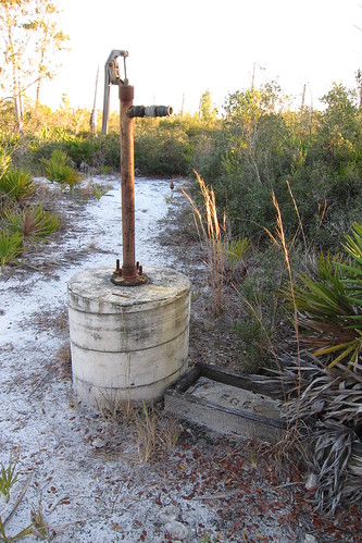
We threw our packs down on the table and Chris went to see if he could get the pump to work. He was feverishly pumping away when all of a sudden he yells at me to bring the 4 liter platypus we have for carrying a larger amount of water in the evenings and I scramble to find it in his pack. At this point water is barely coming out of the pump, but it is enough to fill up the platypus. Chris’ arms are getting tired so he has me switch over but my arm muscles aren’t nearly as strong as his so I don’t last very long. Somehow we manage to fill up the container.
As I sat back down on the picnic table I noticed that a lot of brilliantly red birds are flying around. I mention it to Chris and when I see more I point them out. I was thinking that they’d be some cool migratory bird but turns out they were just robins. Robins are a dingy looking red normally but when the late evening sun is bouncing off them they are a brilliant red that makes them appear more exotic. Little groups fluttered through for awhile until the sun started setting more.
It got very cold that night and we should have zipped our sleeping bags together, but instead we shivered alone in our separate bags. We woke the next morning to frost on the fly and much of the water in the platypus, since we’d left it on the table, frozen. It was a difficult time getting the poles undone that morning and we had to warm them up with our hands to get them out. I brought my gloves on this trip because I knew there might be times like this and I am a wimp with cold. A few times Chris had to borrow them for instances such as this because a few moments out in the cold would stiffen his hands.
Despite the cold it was a clear, crisp morning. The night before we’d made a phone call to Steve, the guy who’d told us that going east on the Okeechobee levee was going to be a no-go and he’d invited us to call him when we got in the Titusville area and he’d pick us up and let us shower and do laundry at his home. We’d told him where we were and that we thought it might be at least two or three more days until we got to Christmas, FL where it was closest to Titusville. Steve mentioned that he might be able to meet us out at Bull Creek near the U.S. 192 the next afternoon but we really didn’t think that would happen.
We left the scrub area in Bull Creek and walked along an old logging tram through some cypress and swamp areas. It was really pretty beautiful in there; no alligators were seen. We met a grandfather and grandson out squirrel hunting but that was the only people we saw while out in Bull Creek. A few more miles and we ended up at the Jane Creek campsite where we saw a man waiting around at the picnic table. I had a feeling it was probably Steve and as we got closer we said hi and found out that it was indeed him.
We sat down and chatted and decided to have an early lunch even though we’d planned to get to the road about another mile further up. It was there that Steve offered to slack pack us on some of the road walk. I’d thrown this idea out to Chris the night before when it was a possibility that Steve might come out to meet us. We hadn’t slack packed a single mile on the AT, well, I guess you could call lightening our load for the climb up Katahdin a bit of a slack, but we’d carried our packs the whole way. After doing some of the other road walks and anticipating a 24 mile road walk (what the book said, the maps were more like 36 miles) I thought that carrying less would be better.
At the road we switched out our packs for Steve’s small backpack and threw some water and snacks in there and off we went down U.S. 192!
2 Comments
Heather Green
Awhile back we shot a wedding, and one of the CF cards was working fine, and then nothing…no photos. Luckily those photos weren’t life or death important on that card so I wasn’t too bummed. I put it to the side and just switched cards. Later once we were home I downloaded the stellar phoenix photo recovery software and it worked…I got every single photo back. Not sure if you still have that card or not, but it’s worth a shot. You do have to pay for the software, but for me it was worth it to get all those photos back.
Patrice
What a journey! I can’t believe how much road walking you had to do day after day in this section. Inevitable, but not as enjoyable. We have a bad habit of eating inside our tent, but maybe we will make a rule with our new tent. We’ll see …