Thru-Hike FAIL: Part I | The Northeast Texas Trail (NETT)
Well, I debated writing this or not. I mean, it is a fail, and after all, who wants to write about their failures?
Earlier this fall Chris and I decided we were going to thru-hike the Lone Star Trail. I did some research and it seemed some sections were closed because the Forest Service is being asinine and calling these sections ‘dangerous’ due to dead trees along the length of the trail. Nevermind that the rest of the forest immediately adjacent to the trail, in the forest, was open. Silly, silly, silly. We were going to hike it anyway. That us until we received our Texas Parks and Wildlife magazine in the mail and it chronicled the recently developed/still-in-development Northeast Texas Trail, a 130-mile rails-to-trails corridor in NE Texas. Hm, this sounded interesting! No one had thru-hiked it and the author who write the article wasn’t able to finish the trail due to overgrowth and landowner issues.
I got online and researched the trail out and it seemed someone was about to start a thru-hike, Tracy Rumsey, a native to the area and with experience around the trail. I followed and joined groups and tried to figure out as much as I could in case she didn’t finish, so we could attempt the trail, too. Plenty of bicyclists ride what they can and then take county or farm roads around to cleared sections. Anyway, Tracy didn’t end up finishing the trail completely, skipping some sections that were too thick or had landowner issues. That led us to finalizing our hiking plans.
To prepare I looked at the available maps online, which are fairly poor information-wise. Google Earth and a set of .gpx tracks for a GPS provided the best hints at the trail. Though it would be fairly easy to follow an old rail bed, there were a few turns around the town of Paris that we wanted to be mindful of and also so we could stay within the trail corridor in case we were going through farmlands. I read up on her reports and other’s reports of the trail to figure out which sections we would be doing some bushwhacking through and where fence jumping may have been necessary. You see once the railroad had been removed from the corridor many landowners inaccurately (or protestingly) assumed they could retrieve that land back. Some landowners have been more receptive than others.
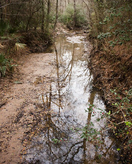
As it came down the wire we noticed that we were going to be expecting rain and/or a wintry mix late Sunday evening and Monday. We figured we’d just go with the flow and maybe only get 10 miles in one day if that’s what we had to do. So, we left Saturday morning with Chris’ step-dad taking us to the eastern end of the trail in New Boston, Texas. The first three miles were pleasant starting off on a paved ‘trail’ through a residential area before turning into a wide, cleared trail as it headed out of town. Another mile or so past that we ran into a construction zone for U.S. 82, where the trail paralleled. I’d read about this but hadn’t expected the mess that we found the trail in—completely destroyed and muddied up. The strip of trees that had lined side of the trail between the trail and the road, providing a buffer to the traffic, had been razed, some in piles still smoldering. This went on for about 9 miles until we reached the town of DeKalb.
Mud, mud, mud. Slipping, sliding, sticking, hip-aching, annoying. I knew it was going to end so we tolerated it.
We arrived into DeKalb, about 12 miles into the trail, about 12:45 on Saturday afternoon. There were plenty of places to eat at along the stretch and we chose Dairy Queen to have lunch. The guy taking our order seemed to understand somewhat that we were backpacking and had a bit of an idea about the trail. Not wanting to linger too long, we ate quickly, and walked over to a gas station to get some water for the next stretch of trail. That’s probably one of the good things about this trail, you don’t necessarily have to carry much food or water as there are plenty of places to stop at along the way. At the gas station another guy in his truck asked us if we were hiking the trail, he’d seen us in New Boston that morning.
Back on the trail after lunch, this section leaving town and onward was much nicer and well maintained. We were almost to returning to the treelined portion of the trail, but still walking adjacent to U.S. 82, when we passed a lumber yard. Two guys were out front working but we kept on passed them until one of them yelled at us and asked if we were walking to Dallas. We turned back around to talk to them and it turned out one of them was friends with the girl Tracy who’d attempted to thru-hike recently. We chatted for awhile and he remarked that Annona had liquor—which meant we were currently either in a dry county or town. Annona was two towns away.
Sometime after this my hips started hurting pretty bad, particularly my right hip. I must have pulled it in the mud, and then of course I could feel blisters beginning to rage on my feet. Not cool.
We kept walking, passing houses and making decent time though I was in pain. While planning this hike I’d uploaded the .gpx tracks into the GPS and also estimated 20 mile campsites and placed them on the GPS. Somehow when Chris went to clear the tracks that had accumulated during our drive to New Boston he deleted everything! Though we had a couple of maps, we now had to estimate based on the GPS. Towards the end of the day on Saturday we started noticing short, green pillars that had a number on them. Initially we hoped they were miles left to the town of Avery. Since we had been making decent mileage we were hoping to move our 20 miles to a 22 mile day and camp just outside of Avery. But, my feet and hips were getting worse, to the point that the slight uphill from the trail to a road that itersected the trail, and I’m talking like two feet here, was incredibly painful to raise my leg up to. Gently swinging my leg as I walked was mostly fine, if I didn’t twitch the leg in some way.
At the last green marker, that had no number on it, I thought perhaps that it was supposed to be a half-mile marker. And then I looked over to the road and saw that the markers had actually been counting down to the county boundary. The sign for entering Red River County was off to the north of the roadway. It was there I told Chris there was no way I was making it to Avery with the pain I had and I immediately took my shoes off to find one blister had busted and another was needing to be popped. I fumbled through our medicine bag and couldn’t find the safety pin we kept in there for sterilizing with a flame and popping blisters after so I made due with fingernail clippers to pop them open. It was instant relief, getting the goo out. We weren’t in a good spot to make camp, so I put my boots back on and we hobbled another half mile past a house and searched for a flat spot next to the trail that was semi-concealed behind the trees from the road behind us. We’d made about 21 miles that day.
As we set up camp, we were in the middle of making dinner when Chris looked over to the adjacent field and saw a hunting blind. Not a good spot to be camping in. I asked him if he wanted to move up a bit but he said no. Of course a little while later after we’d wrapped up dinner we heard an ATV coming our way. I first saw the orange tobogans and then the three people on the ATV. Yep, they were making their way for the blind. Crap.
Chris approached the fence to make our presence known the man that was, I guess the dad to the two kids on the ATV, walking over and I heard him say “How am I supposed to hunt with you sumbitches camping here?” Well, then. I started gathering things up knowing we were going to have to move, but voices calmed and I couldn’t even hear them talking after that. Chris came back and he said that they were going to hunt elsewhere and that was it. Ok. Next time we knew to check for hunting stands before setting up a tent!
It was a long night, over 12 hours in the tent. Tossing and turning, hips and knees hurting, huddling up to get warm, cars and trucks driving by. At one point I was ready to get up and go, but it was still the middle of the night. That’s what happens when you go to bed at 5:45pm.
Part II, photos and a movie to follow.


6 Comments
Curtis
Those 12 hour nights in a tent are the worst.
Francine
Hey, they can’t all be perfect. Best laid plans, and all that jazz.
Thanks for keeping it real and sharing this, though. I wouldn’t call it a failure. Just a series of unfortunate events 😉
Joan
Sometimes trips are like that, but the “failures” sure make for great stories afterwards, even though at the time they suck.
Moosie
🙁
Pingback:
Pingback: